Coordinate Systems and Spatial Reference

Coordinate systems allow geographic datasets to use common locations so that they can be viewed and used together.

This is a big topic in itself (read more), but to get it started, a coordinate system is a reference system used to represent locations within a common geographic framework. There are two types of coordinate systems. One is a Geographic Coordinate System (GCS) which is global or spherical. The other is a Projected Coordinate System (PCS) which provides various mechanisms to project the earth's spherical surface onto a two-dimensional plane. A spatial reference is the georeferencing and coordinate system assigned to geographic data. It defines how geographic data is mathematically transformed onto a flat map. The correct spatial reference settings and transformation allow geographic data that has different coordinate systems to line up in a GIS.

Several coordinate systems are at play within the CT ECO website. We receive a lot of questions about this and what do to when datasets seemingly do not line up. Hopefully this helps.

CT ECO Coordinate Systems

The map and image services available on CT ECO are in WGS 1984 Web Mercator Auxiliary Sphere, which is the current standard for web services. In ArcMap, look for WGS_1984_Web_Mercator_Auxiliary_Sphere. EPSG 3857 (formerly 102100).

The downloadable 2012 tiles and mosaics are in CT State Plane NAD 83 Feet. In ArcMap, look for NAD_1983_StatePlane_Connecticut_FIPS_0600_Feet. EPSG 2234.

The downloadable 2016 tiles and mosaics and downloadable 2019 tiles are mosaics are in the CT State Plane NAD 83 (2011) Feet. This is the most current realization of NAD 83 published by the National Geodetic Survey and is consistent with the national Continuously Operating Reference Stations (CORS) Network. In ArcGIS, look for NAD_1983_2011_Connecticut_ft. EPSG: 6433 (metric) or 6434 (feet)..

Lots of other Connecticut data files, including GIS data available from CT DEEP, are in CT State Plane NAD 83 Feet. EPSG: 2234.

2016 Flight Coordinate System Issues

When using Esri software with the 2016 tiles, sometimes the tiles do not line up properly with other layers. The problem is that, when added to the GIS, the tiles come in as a Custom Projection. We have found two ways to fix this problem.

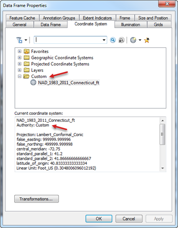
1. Change the coordinate system of the tile or the data frame to the standard CT State Plane NAD 83 (2011) Feet
Projected Coordinate System > State Plane > NAD 1983 (2011) US Feet > NAD 83 (2011) StatePlane Connecticut FIPS 0600 (US Feet) OR search for 6434

Data Frame Properties Thumbnail Data Frame Properties Thumbnail2


2. When using layers with different spatial references together, set the transformation.

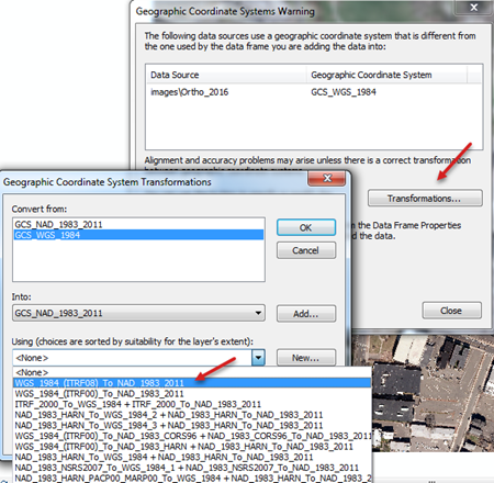
In ArcGIS, a Geographic Coordinate System Warning appears when the layer does not match the spatial reference of the data frame to which it is being added. Choose a transformation, such as the example below where the image service (in GCS WGS 84) is being added to a data frame that is in GCS NAD 83 (2011).

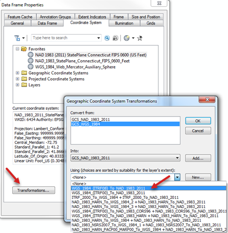
If the warning has come and gone, set the transformation in the Data Frame Properties. Choose the Coordinate system tab and then the Transformation button to choose a transformation.

Coordinate System Transformations Thumbnail dataframe transformation thumbnail

Coordinate System Shortcuts

WKID Display Name
4326 DD (decimal degrees)
DDM (degrees decimal minutes)
DMS (degrees, minutes, seconds)
Lat/Long (WGS 84)
3857 (formerly 102100) x/y Web Mercator (Auxiliary Sphere)
2234 x/y CT State Plane NAD83 Feet


Type Latitude / Y Longitude / X
Decimal Degrees (DD) 41.473098° 72.501002°
Degrees Decimal Minutes (DDM) 41° 28.38591' N 72° 30.06011' E
Degrees Minutes Seconds (DMS) 41° 28' 23.1546" N 72° 30' 3.6066" W
Web Mercator Auxiliary Sphere 5082504.12502 -8070941.20571
CT State Plane NAD83 Feet 733513.36373 1067826.13971

EPSG is a code determined by the EPSG Geodetic Parameter Dataset. WKID (well-known ID) is an Esri ID of a spatial reference system. In these cases, they are the same number.