Download a Small Number of Files
Download a Small Number of Files
To move around the map, use the + to zoom in and the - to zoom out. Pan by holding the left-click and dragging your mouse. If you have a scroll wheel or touch pad on your mouse, scroll up to zoom in and down to zoom out. (Note that a download manager can be installed in your browser. If you plan on clicking and downloading a lot of files, consider using a manager to line the files up and download one at a time - it will help you manage it and help our server load)
To start, EITHER:
- Select a Town from the drop-down list
 or
or - Click on the map.
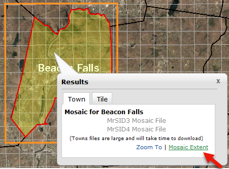
Now that a town is selected (colored in yellow), click on a link to download the file. Find the links in the results window or the tile list.
- The Results window: On the Town tab click to download the town mosaic in either MrSID gen 3 or MrSID gen 4 format. Click the Tile tab to download the selected tile as a GeoTIFF, MrSID gen 3, MrSID gen 4 tile or a DEM (elevation).
- The Tile List : Click on the file type to (.. you guessed it), download the zipped tile..

The Tile List Columnhas some other nifty functions.
- The Magnifier zooms the map to that tile
- Clicking on the Town Name will zoom the map to that town and
- Clicking on the X next to the town name clears out the selected tiles.

Town Mosaics
Town Mosaics
 The town mosaics are available in MrSID gen 3 or MrSID gen 4 formats. The extent of the town mosaics are defined by a rectangle that includes the town boundary. The rectangle extent was used to ensure that no part of any town would be missing. Also, image data must be a rectangular shape so instead of providing you with many black pixels that contained no information, you get a full rectangle of aerial imagery! Lucky you!
To see the extent of the town mosaic that you can download, mouse over Mosaic Extent in the Results window. The orange square outlines the rectangular extent of imagery in that town's mosaic.