A number of services on the CT ECO ctmaps server will be stopped in early June 2025. Most of the services are now available from the CT DEEP Open GIS Data site through a different link. Any connections to the impacted services in map viewers, desktop GIS, or other applications need to be updated to prevent future errors. This blog post includes:
- a list of CTECO ctmaps services that will be impacted and need to be migrated,
- a list of CT ECO ctmaps services that are not impacted, and
- instructions about finding the appropriate connection link on the CT DEEP Open GIS Data site.
Please make necessary modifications as soon as possible to avoid disruptions.
For questions or help, email clear@uconn.edu.
![]() How to find service link on CT DEEP Open GIS Data
How to find service link on CT DEEP Open GIS Data
![]() CT ECO ctraster REST server (not impacted)
CT ECO ctraster REST server (not impacted)
How to find service link
The following instructions assume some familiarity with connecting to services in desktop or online GIS or other related software. The instructions are designed for those who are currently connected to CT ECO ctmaps services that are at end of life and need to be updated.
- Use the links in the table above to locate the data layer About/Summary page on CT DEEP Open GIS Data.
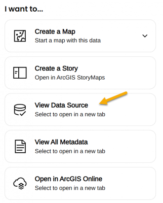 On the lower right side of the page, under the I want to... heading, find View Data Source.
- View Data Source opens the REST URL for the service which is also the connection link.
- Choice 1: Use full service with multiple layers. The full service link can be used for the connection. Sometimes it is one layer and sometimes many. Adding the full service can be convenient but also has may result in limited ability to customize layers within the application. The service link ends in the words FeatureServer or MapServer and does NOT end in a number.
- Choice 2: Add single layer. Each layer can be added individually by clicking on it in the Layers: list of the REST URL. Layers are numbered starting with 0 (usually). Clicking on the layer opens its own URL which ends in a slash and then number. Even a map service with a single layer can be added this way.
Using Bedrock Geology as an example
- Open the CT DEEP GIS Open Data About page for Bedrock Geology.
- Find the I want to... options and the View Data Source link in the lower right side of the page. The link opens the REST page.
- Notice that there are two layers under the Layers: heading - Bedrock Geology Contacts (0) and Bedrock Geology (1).
- To follow Choice 1: Add full service with multiple layers, copy the link that ends in FeatureServer to connect to the full service (both layers).
https://services1.arcgis.com/FjPcSmEFuDYlIdKC/arcgis/rest/services/Connecticut_Bedrock_Geology/FeatureServer
- To follow Choice 2: Add single layer, click on one of the layers, such as Bedrock Geology (1). The link is now for the single layer and ends in a number, /1. Copy the link to connect to the single layer.
https://services1.arcgis.com/FjPcSmEFuDYlIdKC/ArcGIS/rest/services/Connecticut_Bedrock_Geology/FeatureServer/1