state gis office

Update on Imagery and GIS data

Update by Carl Zimmerman, PhD, CT GIS Office 

Flight blocks

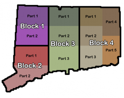
This is an update from the CT GIS Office on the production, review, and publication of the imagery and GIS data collected during the spring 2023 flight. The production is divided into four geographic blocks: Block 1 (northwest), Block 2 (southwest), Block 3 (central), and Block 4 (eastern).

The four steps in the data production process are:

  1. data is collected and processed by the Vendor;
  2. it is reviewed by the GIS Office;
  3. errors and issues are sent back to the Vendor who assesses and corrects them, and then
  4. the final product is delivered to the GIS Office for publication and access by CT ECO and/or the GIS Office. 

Quality Assessment/Quality Control (QA/QC) Process

There are multiple levels in the QA/QC process. First is an initial data assessment and quality review by the Vendor (part of step 1, above) which includes numerous validation steps and a review by their subcontractor. Once received, a second QA/QC review is performed by the GIS Office and participating stakeholders (part of step 2, above) where the team assesses different areas of the different datasets in order to identify any issues or errors within the massive data sets. Currently, we are in the most intense part of the QA/QC process and are evaluating some issues that have been identified by the Vendor and our own review. We are working to determine and negotiate a mutually acceptable set of solutions which impacts the speed of delivery to our users. 

Status of the Imagery and GIS data sets 

True Color Ortho Imagery (RGB) 

The initial delivery of Blocks 1, 2, and 4 to the GISO has occurred.

  • Block 1 errors have been corrected by the Vendor (step 3, above) and should be arriving at the GISO soon (step 4)!
  • Block 2 issues are being reviewed by the GISO now (step 2) and will be sent back to the Vendor for correction this week or next.
  • Block 3 is coming the next two weeks (step 1).
  • Block 4 issues are being reviewed (step 2) and will be sent back to the Vendor next week (step 3).

We expect the full and final imagery dataset to be available in July. In the meantime, CT ECO will host imagery blocks as soon as they are delivered, although they should be considered “beta” versions.

Near Infrared Imagery (NIR) 

The near-infrared band is collected with the true color imagery and is usually treated as one. Unfortunately, a technical issue has been identified near the shoreline for Block 2 where the near-infrared data is “bleeding” into the other areas and is impacting the usability of the data. The delivery (step 1) for the coastal parts of Blocks 2, 3 and 4 is on hold until this issue has been solved and the imagery has been resubmitted by the Vendor to the GISO. Updates to come. 

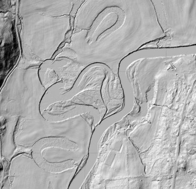
Lidar-Derived DEM and Contours 

The digital elevation model (DEM) is a 2 foot pixel representation of the bare earth elevation. The DEM creation is progressing well and is expected to be finished in the late summer. The 1-foot contours data set is derived from the DEM and will be delivered after the DEM in early fall.  

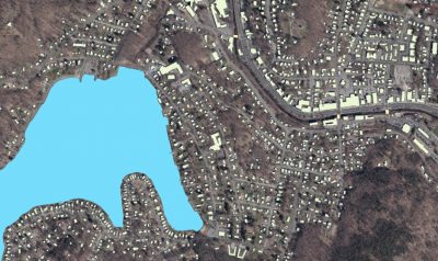
2D and 3D Building Footprints 

The new 2D building footprint layer will include about 1.9 million buildings across Connecticut. The initial review of Blocks 1 and 2 is mostly finished but some quality issues were identified, and iterative improvements are being performed. Blocks 3 and 4 will not be delivered until the quality issue is resolved. This data set will be available end of summer or early fall. The 3D Building Footprints will be completed last to ensure that all iterative corrections are accounted for. Expect the 3D Building Footprints in the fall.   

Classified Lidar Points

The classified lidar is meeting specifications for capture density, overlap, and classification quality. This data set will be delivered in the fall after the other data sets are completed and produced. 

Lakes, Streams, and Shoreline Polygons and Polylines 

These data sets are used for creation of other datasets, particularly the elevation. They will be delivered in the summer. 

CT Imagery Delivery Update

Written by Carl Zimmerman, PhD, GIS Coordinator, CT GIS Office (email: carl.zimmerman@ct.gov

The first wave of Imagery, Elevation, and GIS data are now being delivered to the GIS Office and are undergoing a Quality Assurance review. The imagery data we have seen so far (NW CT) looks quite good. A nice example of the quality is the natural color imagery capture of the Kent School on the banks of the Housatonic River.

2023 aerial example, Kent School
2023 Ortho aerial imagery of The Kent School

The bare earth surface dataset, called a Digital Elevation Model (DEM), also looks great with remarkable detail. Below is an example of remnant ox bows (old river meanders) captured underneath the tree canopy that highlights geomorphology features captured by the Lidar data.

2023 DEM sample
2023 bare earth DEM

In addition, we are receiving GIS data such as the building footprints and water features. We are expecting to have around a million building footprints delivered by the end of the project that cover every town in Connecticut.

2023 GIS deliverables, Winsted example
Example of GIS deliverables, Highland Lake just west of downtown Winsted

Delivery Schedule

Flight blocks
2023 Flight Blocks and Parts

The delivery schedule has changed due to issues related to “warping” and refining the True Ortho process for cleaning up buildings in urban centers. We hope that as the Quality Assurance/Quality Control (QA/QC) process continues, the Vendor will improve their delivery speed. The new timeline is focused on completing more rural areas first followed by urban areas.

Block 1 in northwest CT was delivered first and the GIS Office will receive Block 2, part 1 and Block 4, parts 1 and 2 in the next week. The southwest CT coast will be delivered next (Block 2, part 2) along with the rest of eastern CT (Block 4, parts 3, 4, & 5). Following those, central CT (Block 3) will be delivered.

The table below includes an estimated timeline for the initial delivery to the GIS Office and final availability. For reference, following the initial delivery to the GIS Office, the following happens:

  1. the geospatial data is reviewed by the GIS Office and participating stakeholders;
  2. the review is incorporated into the dataset by the Vendor; and then
  3. the near-final dataset is returned to the GIS Office, spot checked, and is then ready for distribution.
  4. the distributors (CT ECO for aerial imagery and raster-based elevation, and the GIS Office for vector datasets) can begin work on web distribution and download which will happen as fast as possible.

In addition, 3D buildings and contours (which are derived products) will be produced after the final approval of all other data to ensure that these products have the best possible underlying quality which will be later in the summer. We appreciate your patience as we try to deliver the best possible products.

Location (type) Block Initial Vendor Delivery Estimated Availability
NW CT (imagery ) Block 1 delivered April
NW CT (GIS & elev. ) Block 1 delivered April
SW CT (imagery) Block 2, part 1 early March April-May
SW CT (imagery) Block 2, part 2 early April May
SW CT (GIS elev.) Block 2 mid-March May
Eastern CT (imagery) Block 4, parts 1,2 early March April
Eastern CT (imagery) Block 4, parts 3,4,5 April May-early June
Eastern CT (GIS & elev.) Block 4 early June July
Central CT (imagery) Block 3 May July
Central CT (GIS  & elev.) Block 3 early May July


CT GIS Office Newsletter Vol 1, Issue 2

GIS Office Newsletter, Volume 1 | Issue 2

GIS Office Newsletter, Volume 1, Issue 2
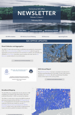
Volume 1, Issue 2 of the GIS Office newsletter is out. It announces the new, seamless 2023 parcel layer, the 2023 Annual Report, and the new housing dashboard. It also includes updates about broadband mapping, stakeholder outreach, addressing, the strategic plan, aerial imagery acquisition update, and more.

It also provides a summary of the recent GIS Advisory Council meeting, some cool resources, and upcoming events. Check it out!

CT Imagery and Lidar Delivery Schedule

Written by Carl Zimmerman, PhD, GIS Coordinator, CT GIS Office (email: carl.zimmerman@ct.gov

We are all excited about the arrival of the new data and we have received questions about when it will be available. The very high resolution and quality of both the aerial imagery and Lidar create VERY LARGE files which are time-consuming to process and review. Because of this, new vendor workflows and algorithms were required and took some extra time. We know that new imagery is a top priority and the order of dataset delivery has also been altered so that imagery is received first. We are working as fast as possible while maintaining the highest data quality. 

The following describes the delivery and timeline and we will provide updates when available. 

2023 Data Delivery blocks

Delivery Blocks

The data is broken into four delivery sections: northwest CT (light blue, first), southwest CT (dark blue), the CT River Valley (green), and finally eastern CT (brown).

Schedule

Unfortunately, there is no instant gratification in the schedule. The tasks that need to be completed before the data can be finalized and provided include the review, acceptance of edits, final delivery, and then public access. Each step takes some time – there are over 20,000 imagery tiles, billions of Lidar classified points, and over a million buildings.

If you are interested in helping to review the datasets for your town or region, please reach out. There will be a web portal and we will have some training soon to demonstrate its use. 

Tentative data schedule  Block 1
Northwest CT
Block 2
Southwest CT
Block 3
Central CT
Block 4
Eastern CT
Imagery
1. Initial data delivery via online review tool 12/8/2023 1/19/2024 2/28/2024 3/31/2024
2. Data review* (QAQC**) deadline 1/10/2024 2/14/2024 3/27/2024 5/1/2024
3. Final imagery delivery to GIS Office 1/25/2024 3/1/2024 4/15/2024 5/15/2024
Lidar and GIS Data
4. Initial data delivery via online review tool 1/31/2024 2/29/2024 4/30/2024 5/31/2024
5. Data review* (QAQC**) deadline 3/1/2024 4/1/2024 6/1/2024 7/1/2024
6. Final Lidar and GIS data delivery to GIS Office 4/1/2024 5/1/2024 7/1/2024 8/1/2024

*Data review will be lead by the GIS Office with help from the Data Acquisition Working Group and stakeholders
**QAQC stands for Quality Assurance and Quality Control

2023 Data Acquisition Update

Hi CT GIS Community:

This is Carl Zimmerman (GIS Coordinator) from the CT GIS Office, and I wanted to give you a quick update on the 2023 imagery acquisition that many of you are wondering about. After some technical and quality delays around the many buy-ups of this complicated and high-resolution data capture (e.g., Imagery, LiDAR, elevation, and GIS products (such as 3d buildings)), we have a firm schedule.

Imagery will be delivered in four blocks this Spring, and the Lidar and GIS products will follow approximately two months behind the imagery in a similar pattern. Expect to see some draft imagery from CT ECO starting in early Spring and more added over the following few months. Lidar, elevation, and GIS Products will come late in the Spring and early Summer.

For us to have the best quality for this very large data set(s), four critical steps need to be finished: 1) the imagery data will be QA/QC’d by an internal subcontractor for the Vendor; 2) the GIS Office and GIS Community will review it; 3) the identified errors will be corrected by the Vendor; and 4) the finished data will be put into web services or downloadable format for you to consume. Please be patient as we get moving on this large and detailed project. More updates to follow on our progress.

Finally, I will be reaching out to some of you in December and the early Winter for your assistance in reviewing the data. If interested in helping with this large project let Alfredo Herrera or myself know.

Thanks,
Carl

Alfredo.herrera@ct.gov (CT GIO)
Carl.zimmerman@ct.gov 

CT GIS Office Newsletter

GIS Office Quarterly Newsletter, Volume 1 | Issue 1

GIS Office Newsletter, Volume 1, Issue 1
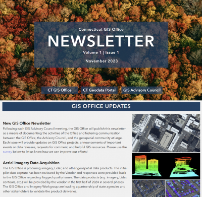
The very first newsletter of the CT GIS Office is out! It includes exciting data updates about aerial imagery data acquisitions, parcel and CAMA data, and broadband mapping.

It explains the Geospatial Strategic Plan including the five strategic goals and their related activities and objectives.

It also provides a summary of the recent GIS Advisory Council meeting, some cool resources, and upcoming events. Check it out!

CT Geodata Portal

The Geodata Portal will provide access to high-quality geospatial data for Connecticut data practitioners across all sectors and industries. By hosting, aggregating, and sharing trusted and reliable geospatial data, users can expect to easily find trusted data to meet their needs. The Geodata Portal is available at geodata.ct.gov and will build on the success of and be integrated with the state’s open data portal. The Geodata Portal contains, maps, apps, and services from multiple authoritative data sources including the CT Dept. of Transportation (DOT), CT Dept. of Energy and Environmental Protection (DEEP), and CT ECO.