Statewide, 3 inch resolution, 4 band orthoimagery AND statewide Quality Level 1 Lidar (minimum of 15 points per square meter inland a minimum of 20 points per square meter along the coast) was collected in the spring of 2026. The project was managed by the CT State GIS Office with the Aerial Imagery Acquisition Workgroup. See Funding and Project Management below for more information.

2026 Aerial Imagery
VIEW
CONNECT
DOWNLOAD
Aerial Imagery Viewer
coming soon
for all users
The 2026 imagery will be part of the online, interactive Aerial Imagery Viewer that contains all of Connecticut's statewide, digital aerial imagery. It will also be available in other CT ECO Viewers.
> Aerial Imagery Viewer Help
Image Services
coming soon
for advanced users
On the Map and Image Services page, look for Imagery-Spring Statewide and then 2026 Spring 4 band, 3 inch. Both a dynamic service and tile service will be available.
> How to Connect to Services
> Service FAQs
Download
coming soon
for GIS users
Use the CT ECO Image and Elevation Download tool for aerial imagery tiles as GeoTIFF tile, MrSID Generation 3, or MrSID Generation 4. Town mosaics are available as MrSID Generation 3 and MrSID Generation 4. See Image Formats for more information.
2026 Lidar Elevation
VIEW
CONNECT
DOWNLOAD
Elevation Viewer
coming soon
for all users
The 2026 elevation will be part of the online, interactive Elevation Viewer that contains statewide elevation, hillshade, shaded relief, slope, aspect, intensity, and contours. Some elevation layers are available in other CT ECO Viewers.
> Elevation Viewer Help
Elevation Services
coming soon
for advanced users
On the Map and Image Services page, look for Elevation Layers from 2026.
> How to Connect to Services
> Raster Processing Templates: Accessing and Applying for Elevation
> Services FAQ
Download
coming soon
for GIS users
> Use the CT ECO Image and Elevation Download tool for elevation as DEM tile (GeoTIFF), vector contour files (geodatabase, shapefile), or point cloud (LAZ).
> From NOAA, download Lidar points or DEMs in bulk, or use the Data Access Viewer to select an area and download.

2026 Buildings
DOWNLOAD
CONNECT
BLOCKS
2D Buildings Service
coming in 2027
for advanced users
The 2D Building footprint service will be available on the CT Geodata Portal as a Feature Service.
DOWNLOAD
CONNECT
BLOCKS
3D Building Service
coming in 2027
for advanced users
The 3D Building service will be available on the CT Geodata Portal as a 3D Scene Services and a 3D Web Scene.
Metadata
Funding and Project Management
The 2023/2026 flight project is managed by Alfredo Herrera at the CT State GIS Office with assistance from the Aerial Imagery Acquisition Workgroup. Members contributing to the 2026 flight are Erik Snowden, lead (CRCOG), Dan Czaja (DESPP), Stuart Deland (DEEP), Thad Dymkowski (DOT), Emily Wilson (UConn), and Sarah Hurley (GIS Office).
The project is funded by the American Rescue Plan with contributions from the CT Department of Transportation and the CT Department of Public Protection and Emergency Services.
Deliverables
Deliverables
Imagery
- Statewide, leaf-off, 4-band orthoimagery tiles with 3 inch pixel resolution in GeoTIFF and MrSID formats, tide coordinated
- True orthoimagery (nadir) over urban center and tall bridges and overpasses
- Town mosaics in MrSID format
Elevation
- Statewide Quality Level 1 (QL1) Lidar point cloud with a minimum of 15 points per square meter with 13 classes, hydro flattened
- Bare earth 2 foot resolution DEM tiles in GeoTIFF format
- Lidar-derived contours lines (1 and 5 feet)
- Lidar-derived building footprints for all structures greater than 100 square feet.
- 3D Terrain Model with 3D buildings
Documentation
- FDGC/USGS compliant metadata
- Reports including data acquisition, survey, production, control and calibration and quality assurance and accuracy
Citation
Please site the imagery as below. The elevation would be similar - just replace the data layer name.
CT State GIS Office. (2026). 2026 Aerial imagery. Retrieved from https://maps.cteco.uconn.edu/data/flight2026/.
Image and Elevation Formats
Image Formats
| GeoTIFF | Highest quality image file, but also largest file size |
| MrSID Generation 4 | Compressed image file that supports all 4 image bands (blue, green, red, near-infrared) |
| MrSID Generation 3 | Compressed image file with the smallest file size because it contains only 3 image bands (blue, green, red) |
TIFF or TIF stand for Tagged Image File Format and is used for storing raster images. Geo indicates that the TIF has a word file, called TWF that stores geographic information about the raster file.
MrSID stands for MultiresolutionSeamless Image Database. It is a way of compressing imagery so that it can be quickly viewed. LizardTech pioneered the MrSID technology. With each Generation, LizardTech has improved the functions of the MrSID files. MrSID Generation 3 improved upon Generation 2 by supporting unlimited files sizes, lossless encoding with optimization and manipulation options. MrSID Generation 4 improved upon Generation 3 by supporting multi-spectral and hyper-spectral imagery and an improved mechanism for composite mosaicking.
Elevation Formats
DEM - a raster based (pixel) Digital Elevation Model. The tiles available for download are in GeoTIFF format.
LAS/LAZ - a Lidar data exchange file which is a standard format for airborne lidar point data. LAZ is the zipped and compressed LAS.
Tiles and Sizes
Delivery Area and Tile Grid
Tiles and Sizes
The following are values from the 2023 flight but we except the 2026 to be similar.
Aerial Imagery
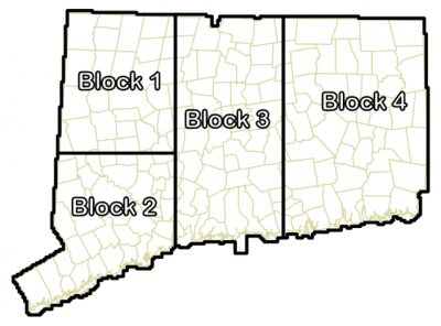
| Block | Number of Tiles | File size: GeoTiff (GB) |
File Size: MrSID3 RGB (GB) |
File Size: MrSID3 CIR (GB) |
File Size: MrSID4 (GB) |
| Block 1, part 1 | 2110 | 793 | 58.9 | 58.9 | 78.6 |
| Block 1, part 2 | 2157 | 803 | 60.8 | 60.8 | 80.4 |
| Block 2, part 1 | 2252 | 843 | 64.1 | 64.1 | 85.1 |
| Block 2, part 2 | 2220 | 833 | 63.2 | 63.2 | 83.9 |
| Block 3, part 1 | 1956 | 729 | 55.3 | 55.3 | 75.7 |
| Block 3, part 2 | 2016 | 752 | 57.0 | 57.0 | 75.7 |
| Block 3, part 3 | 2612 | 974 | 73.9 | 73.9 | 98.2 |
| Block 4, part 1 | 1467 | 547 | 40.9 | 40.9 | 54.7 |
| Block 4, part 2 | 1512 | 564 | 42.2 | 42.2 | 56.3 |
| Block 4, part 3 | 1712 | 639 | 48.5 | 48.5 | 64.4 |
| Block 4, part 4 | 1672 | 623 | 47.3 | 47.3 | 62.8 |
| Block 4, part 5 | 1695 | 632 | 48.0 | 48.0 | 63.7 |
| TOTAL | 23,381 | 8.73 TB | 661.3 GB | 661.3 GB | 878.2 GB |
Elevation
| File size: Contour gdb |
Number of contour sub-blocks | File size: DEM GeoTIFFs | File size: Point Cloud (laz) |
Number of files | |
| Block 1 | 4.98 GB | 12 | 30.4 GB | 1.27 TB | 4267 |
| Block 2 | 4.33 GB | 12 | 31.5 GB | 1.36 TB | 4472 |
| Block 3 | 5.66 GB | 12 | 47.6 GB | 1.78 TB | 6584 |
| Block 4 | 7.45 GB | 18 | 57.8 GB | 1.76 TB | 8058 |
| TOTAL | 22.42 GB | 54 | 167.3 GB | 6.17 TB | 23,381 |
Aerial Imagery
The town mosaics are a MrSID mosaic that is a rectangle that fully includes each municipality with a small buffer from the borders. The range of file sizes is due to the shape and therefore size of the rectangle mosaics.
| Number
|
File size: MrSID 3 RGB | File size: MrSID 3 CIR |
File size: MrSID 4 a (lower compression) |
File size: MrSID 4 b (lower compression) |
|
| Town mosaics | 169 | 611 GB | 611 GB | 1.99 TB | 816 GB |
| (range from 0.9 to 8.8 GB) | (range from 0.9 to 8.8 GB) | (range from 2.5 - 30.3 GB) | (range from 1.2 - 11.8 GB) |
The Facts
23,381 tiles covering Connecticut. Each tile is 2500 ft x 2500 ft, 0.224 sq miles, 143.5 acres, and 58 hectares.
The Facts: Imagery
Statewide. 4 bands (red, green, blue, near-infrared). 3 inch pixels (3 inch resolution). GeoTIFFs. MrSIDs Generation 3 and Generation 4. CT State Plane NAD 83 (2011)* Feet. Captured in March and April 2026 (leaf off). Tide coordinated.
The Facts: Elevation
Statewide. USGS Quality Level 1, minimum of 15 points per sq meter. Minimally ground/non-ground classification. LAS files (point cloud). Bare earth 2 foot pixel raster tiles (called a Digital Elevation Model or DEM). 1 foot and 5 foot contours derived from Lidar. Captured in March and April 2026 (largely leaf off). Tide coordinated.
* NAD 83 (2011) is the most current realization of NAD 83 published by the National Geodetic Survey and is consistent with the national Continuously Operating Reference Stations (CORS) Network.