 Written by Jacob Isleib, State Soil Scientist
The USDA NRCS, Soil and Plant Science Division refreshes the publicly available soil survey database once a year. This Annual Soils Refresh (ASR) provides new soils data, updates to existing soils data, and new soil interpretations. The ASR also ensures all official soils data adhere to the same standards.
This year’s update to soil survey data in the State of Connecticut brings marked changes.
A summary of these changes is listed here.
1. Updated Farmland of Statewide Importance Criteria
To help maintain the productive capacity of American agriculture, the U.S. Department of Agriculture’s Natural Resources Conservation Service (NRCS) has developed criteria and guidelines to inventory important farmlands. Earlier this year, Connecticut NRCS proposed to update its farmland designation criteria for Farmland of Statewide Importance to allow for “not more than 3 percent of the soil surface is covered by stones 10 in (25 cm) to 24 in (60 cm) diameter.” This change would allow for some very stony soil map units to be designated as Farmland of Statewide Importance. The result of these changes is a more equitable designation across Connecticut, as these designations are used to assess eligibility and ranking for certain USDA program benefits. Further, the new designations are consistent with criteria/designations in other states of our region such as Massachusetts.
These farmland designation criteria changes result in the following changes to the Soil Survey of the State of Connecticut:
- 339,153 acres changed to Farmland of Statewide importance. Some of this acreage was previously designated as Locally Important Farmland in select towns. This change to Farmland of Statewide importance supersedes the Locally Important Farmland designation, resulting in a more equitable designation across the state as these designations are used to assess eligibility and ranking for certain USDA program benefits.
- 8 map units currently designated as Locally Important Farmland in select towns would not be changed to Farmland of Statewide Importance, so the Locally Important designation does not become obsolete as a result of the proposed change. These unchanged map units are associated with bedrock-controlled landforms. Connecticut and Massachusetts currently have consistent farmland designation criteria as related to amount of bedrock outcrop/exposures.
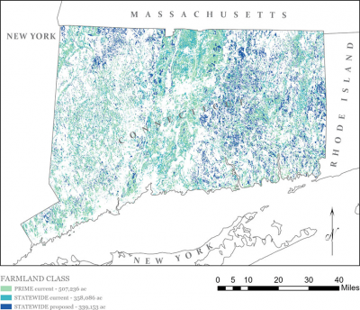
Figure 1. The darker blue areas labeled “STATEWIDE proposed” are now considered Farmland of Statewide Importance in the FY24 soil survey data.
3. Connecticut Soil Survey Area Split into Western and Eastern Parts
Users that download the spatial and tabular soil survey data for use in GIS and/or Access will notice a significant change to how the Connecticut data is packaged. Due to new data serving limitations, the State of Connecticut (statewide) soil survey area (symbolized as CT600) needed to be split into at least two parts. The former and current soil survey areas are shown below for illustration.
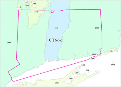
Figure 3.1. Former Soil Survey Area boundary for CT600 (Soil Survey of the State of Connecticut) with MLRA boundaries
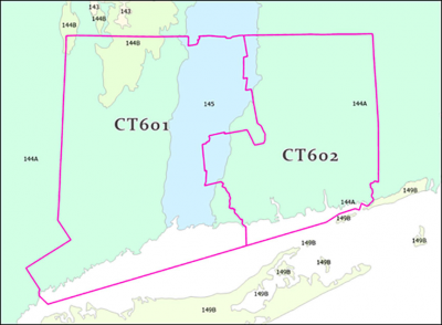
Figure 3.2. New Soil Survey Area boundaries; CT601 (Soil Survey of the State of Connecticut, Western Part) and CT602 (Soil Survey of the State of Connecticut, Eastern Part)
A few criteria were used to develop the split feature (i.e., the line used to split the soil survey area into two parts). The main criteria were that the split should result in two large parts of approximately similar size and the boundary should attempt to negotiate both the legacy counties and new planning regions (aka “county equivalents”). The feature is shown in red in Figure 3.3.
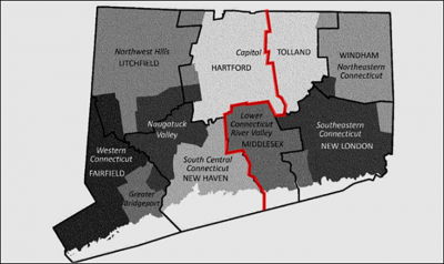
Figure 3.3. The relationship between legacy counties and county-equivalents (Planning Regions). County boundaries are shown as thick lines; names are labeled in standard font in all caps. The county-equivalents are shaded; names are in italics. Original black and white figure from US Census.
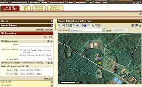
The new data can be downloaded by visiting Web Soil Survey, click “Start WSS”, select “Download Soils Data” tab, and filter by state.
Updated Soils Web Services on CT ECO and CT DEEP Open GIS
To facilitate easier access to soil survey map unit data and select popular soil interpretations, NRCS has partnered with UConn CLEAR and CT DEEP to provide web service layers of soil survey-derived data. The newly updated layer links are available on the CT ECO Services page for:
- All Soils – this is the soil map unit polygon data from the latest version of SSURGO
- Farmland classification – see item 1 above for a detailed explanation of this data and how it was updated for the Fall 2023 release
- CT Inland Wetlands
- Hydric Soil Rating
- Soil Parent Material Name
- Subsurface Sewage Disposal Systems
- Soil Drainage Class
All these new web service layers were generated using the latest version of soil survey data.
If you have any questions about new edits to Connecticut soil survey data, please contact Jacob Isleib at Jacob.isleib@usda.gov.