Written by Carl Zimmerman, PhD, GIS Coordinator, CT GIS Office (email: carl.zimmerman@ct.gov)
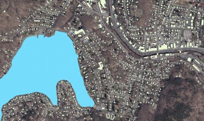
The first wave of Imagery, Elevation, and GIS data are now being delivered to the GIS Office and are undergoing a Quality Assurance review. The imagery data we have seen so far (NW CT) looks quite good. A nice example of the quality is the natural color imagery capture of the Kent School on the banks of the Housatonic River.

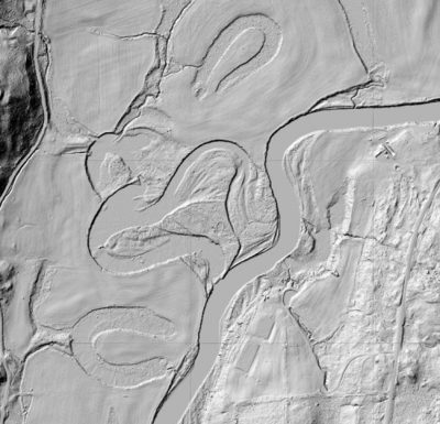
The bare earth surface dataset, called a Digital Elevation Model (DEM), also looks great with remarkable detail. Below is an example of remnant ox bows (old river meanders) captured underneath the tree canopy that highlights geomorphology features captured by the Lidar data.
In addition, we are receiving GIS data such as the building footprints and water features. We are expecting to have around a million building footprints delivered by the end of the project that cover every town in Connecticut.
Delivery Schedule
The delivery schedule has changed due to issues related to “warping” and refining the True Ortho process for cleaning up buildings in urban centers. We hope that as the Quality Assurance/Quality Control (QA/QC) process continues, the Vendor will improve their delivery speed. The new timeline is focused on completing more rural areas first followed by urban areas.
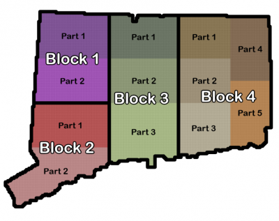
Block 1 in northwest CT was delivered first and the GIS Office will receive Block 2, part 1 and Block 4, parts 1 and 2 in the next week. The southwest CT coast will be delivered next (Block 2, part 2) along with the rest of eastern CT (Block 4, parts 3, 4, & 5). Following those, central CT (Block 3) will be delivered.
The table below includes an estimated timeline for the initial delivery to the GIS Office and final availability. For reference, following the initial delivery to the GIS Office, the following happens:
- the geospatial data is reviewed by the GIS Office and participating stakeholders;
- the review is incorporated into the dataset by the Vendor; and then
- the near-final dataset is returned to the GIS Office, spot checked, and is then ready for distribution.
- the distributors (CT ECO for aerial imagery and raster-based elevation, and the GIS Office for vector datasets) can begin work on web distribution and download which will happen as fast as possible.
In addition, 3D buildings and contours (which are derived products) will be produced after the final approval of all other data to ensure that these products have the best possible underlying quality which will be later in the summer. We appreciate your patience as we try to deliver the best possible products.
| Location (type) | Block | Initial Vendor Delivery | Estimated Availability |
| NW CT (imagery ) | Block 1 | delivered | April |
| NW CT (GIS & elev. ) | Block 1 | delivered | April |
| SW CT (imagery) | Block 2, part 1 | early March | April-May |
| SW CT (imagery) | Block 2, part 2 | early April | May |
| SW CT (GIS elev.) | Block 2 | mid-March | May |
| Eastern CT (imagery) | Block 4, parts 1,2 | early March | April |
| Eastern CT (imagery) | Block 4, parts 3,4,5 | April | May-early June |
| Eastern CT (GIS & elev.) | Block 4 | early June | July |
| Central CT (imagery) | Block 3 | May | July |
| Central CT (GIS & elev.) | Block 3 | early May | July |