cteco

Input sought for Long Island Sound Blue Plan review

Feedback is sought for a five-year review and update of the Long Island Sound Resource and Use Inventory and the Long Island Sound Blue Plan.

An informational letter contains background, how to access the survey (10 minutes in length), contacts, and more. The survey is intended for all including those not familiar with the Blue Plan.

information icon Informational letter including survey link

CT DEEP logo  Long Island Sound Blue Plan at CT DEEP

viewers icon Long Island Sound Blue Plan Viewer on CT ECO

Urgent: Migrate Select Services on ctmaps Server

A number of services on the CT ECO ctmaps server will be stopped in early June 2025. Most of the services are now available from the CT DEEP Open GIS Data site through a different link. Any connections to the impacted services in map viewers, desktop GIS, or other applications need to be updated to prevent future errors. This blog post includes:

  1. a list of CTECO ctmaps services that will be impacted and need to be migrated,
  2. a list of CT ECO ctmaps services that are not impacted, and
  3. instructions about finding the appropriate connection link on the CT DEEP Open GIS Data site.


Please make necessary modifications as soon as possible to avoid disruptions. 

For questions or help, email clear@uconn.edu.

information icon  How to find service link on CT DEEP Open GIS Data

map services icon CT ECO ctmaps REST server

CT DEEP logo CT DEEP Open GIS Data

CT GIS Office logo CT Geodata Portal

map services icon CT ECO ctraster REST server (not impacted)

Services to Migrate NOW

CT ECO SERVICE

DEEP OPEN DATA PAGE or NOTE

BASE MAP
CT_Base_Map Retired, not being replaced
CT_Bordering_States Northeastern States State Boundary Set
Transportation Connecticut Airports
Connecticut Airports FAA
Connecticut Railroads
Routes (Recommended: CTDOT Roadways)
BIOSCIENCE
Critical_Habitat Critical Habitats
CT_NWI_Wetland_Functions_2010 currently under review, check back
DEEP_FreshwaterFish DEEP Fisheries Stream Survey Points
Natural_Diversity_Database_Areas Natural Diversity Database
Tidal_Wetlands_1970s Tidal Wetlands 1970s
Tidal_Wetlands_1990s Tidal Wetlands 1990s
COASTAL
BluePlan_HU_FishShellfish Service is not impacted but consider using Dept. of Ag  CT Shellfish service
CT_Coastal_Managment_Areas Coastal Area and Boundary Polygon
CT_Hurricane_Evacuation_Zones_2014  new service coming soon, check back
CT_Hurricane_Surge_Inundation_2012 CT Hurricane Surge Inundation
CTCoastalMaintainedChannels currently under review, check back
Eelgrass_Beds_2002_2012 Eelgrass Beds 2002 Set
Eelgrass Beds 2006 Set
Eelgrass Beds 2009 Set
Eelgrass Beds 2012 Polygon
Eelgrass_Beds_2002_2017 Eelgrass Beds 2017 Polygon (Also contains 2002, 2006, 2009, and 2012 linked above)
LISBathymetry 
Bathymetric Contours in Meters for Long Island Sound
LIS_Environmental_Observation new service coming soon, check back
Shoreline_Change_Long_Term currently under review, check back
Shoreline_Change_Short_Term currently under review, check back
Shoreline_Change_Supplemental_Data currently under review, check back
ELEVATION
CT_Contours_2000 Service retired, download available
Lake_Bathymetry  Lake Bathymetry Contours
GEOLOGY
Bedrock Bedrock Geology
Bedrock_Terrane Bedrock Terrane
Erosion_Susceptibility  Erosion Susceptibility
Quaternary_Geology Quaternary Geology
Surficial_Aquifer_Potential  Surficial Aquifer Potential
Surficial_Aquifer_Texture Surficial Aquifer Texture
Surficial_Materials  Surficial Materials
HYDROGRAPHY
Hydrography CT Hydrography
Named__Waterbody  Named Waterbody
Waterbody Retired, not being replaced
OPEN SPACE
1997_Municipal_and_Private_Open_Space 1997 Municipal and Private Open Space
DEEP_Property DEEP Property
DOT_Scenic_Land_Strips  new service coming soon, check back
Federal_Open_Space_1997  Federal Open Space
Open_Space This is a grouping of services on this list
Parcels_for_Open_Space_Mapping  Although the service exists through CT DEEP, consider using updated parcels from the CT GIS Office.
Protected_Open_Space_Mapping 2011 Protected Open Space Mapping
POLITICAL
Administrative_Boundary_Index USGS Topographic Quadrangle Index new service coming soon, check back
Regional Councils of Governments (Consider CT Councils of Government or CT Planning Regions from the CT Geodata Portal)
US Congress Districts 2011-2020 (Consider CT US Congressional Districts on the CT Geodata Portal)
CT House Districts 2011-2020 (Consider CT House Districts on the CT Geodata Portal)
CT Senate Districts 2011-2020 (Consider CT Senate Districts from the CT Geodata Portal)
CT County Index (Consider CT Counties for the CT Geodata Portal)
Connecticut_Towns  CT DOT Municipalities (Consider CT Municipalities (with FIPS) from the CT Geodata Portal)
Northeast_US_Boundaries Northeastern State Boundaries (Also called Northeast US Boundaries Index)
Northeasters States County Boundaries
Northeastern States Town Boundaries
SOILS
Farmland_Soils  Soils Farmland Classification
Hydric_Soils Soils Hydric Rating
Inland_Wetland_Soils  Soils Inland Wetland
Potential_for_Subsurface_Disposal_Systems  Soils Subsurface Sewage Disposal Systems
Soil_Flooding_Class Retired, not being replaced
Soil_Parent_Material  Soils Parent Material Name
Soils Soils All Soils
WATER RESOURCES
Aquifer_Protection_Areas Aquifer Protection Areas
Assessed_and_Impaired_Waterbodies_2006 Impaired 2006 River Lake Estuary
Assessed_and_Impaired_Waterbodies_2008 Impaired 2008 River Lake Estuary
Assessed_and_Impaired_Waterbodies_2010  Impaired 2010 River Lake Estuary
Assessed_and_Impaired_Waterbodies_2012  Impaired 2012 River Lake Estuary
Assessed_and_Impaired_Waterbodies_2014 Impaired 2014 River Lake Estuary
Assessed_and_Impaired_Waterbodies_2016 Impaired 2016 River Lake Estuary
Assessed_and_Impaired_Waterbodies_2018 Impaired 2018 River Lake Estuary
Assessed_and_Impaired_Waterbodies_2020 Impaired 2020 River Lake Estuary
Water_Quality_Classifications Surface Water Quality Classifications
Ground Water Classifications
WATERSHEDS
CT_Watershed_Boundary_Dataset_8_HU new service coming soon, check back
CT_Watershed_Boundary_Dataset_10_HU new service coming soon, check back
CT_Watershed_Boundary_Dataset_12_HU new service coming soon, check back
Basins Drainage Basin Set
Local_Basins Local Drainage Basin Set
Subregional_Basins Subregional Drainage Basin Set
Regional_Basins  Regional Drainage Basin Set
Major_Basins Major Drainage Basin Set

How to find service link

The following instructions assume some familiarity with connecting to services in desktop or online GIS or other related software. The instructions are designed for those who are currently connected to CT ECO ctmaps services that are at end of life and need to be updated.

  1. Use the links in the table above to locate the data layer About/Summary page on CT DEEP Open GIS Data.
  2. Add service graphic
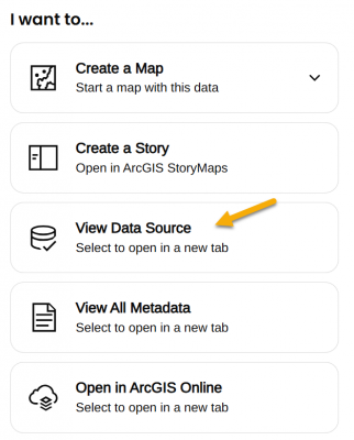
On the lower right side of the page, under the I want to... heading, find View Data Source.
  3. View Data Source opens the REST URL for the service which is also the connection link.
    1. Choice 1: Use full service with multiple layers. The full service link can be used for the connection. Sometimes it is one layer and sometimes many. Adding the full service can be convenient but also has may result in limited ability to customize layers within the application. The service link ends in the words FeatureServer or MapServer and does NOT end in a number.
    2. Choice 2: Add single layer. Each layer can be added individually by clicking on it in the Layers: list of the REST URL. Layers are numbered starting with 0 (usually). Clicking on the layer opens its own URL which ends in a slash and then number. Even a map service with a single layer can be added this way.

Using Bedrock Geology as an example

  1. Open the CT DEEP GIS Open Data About page for Bedrock Geology.
  2. Find the I want to... options and the View Data Source link in the lower right side of the page. The link opens the REST page.
  3. Notice that there are two layers under the Layers: heading - Bedrock Geology Contacts (0) and Bedrock Geology (1).
  4. To follow Choice 1: Add full service with multiple layers, copy the link that ends in FeatureServer to connect to the full service (both layers).
    https://services1.arcgis.com/FjPcSmEFuDYlIdKC/arcgis/rest/services/Connecticut_Bedrock_Geology/FeatureServer
  5. To follow Choice 2: Add single layer, click on one of the layers, such as Bedrock Geology (1). The link is now for the single layer and ends in a number, /1. Copy the link to connect to the single layer.
    https://services1.arcgis.com/FjPcSmEFuDYlIdKC/ArcGIS/rest/services/Connecticut_Bedrock_Geology/FeatureServer/1

Batch Download Files from CT ECO Download Tool

New Download Manager Recommendation! 

The CT ECO Download Tool is a great way to interactively select files for download. It also provides export in terms of a csv file of links. Systemically downloading from the links requires a separate tool or script. The CT ECO Download Manager help page is now updated with instructions about how to use the free and open source tool, JDownloader 2.

JDownloader 2 provides an easy interface to paste the list of download links and then systematically download and unzip (extract) them. Check out the page for details.

If you have another slick way download a list of files from CT ECO, please let us know clear@uconn.edu.

download icon  CT ECO Download Tool

information icon  CT ECO Download Manager help page


2023 Elevation Services Published

Elevation Image Services

The elevation, hillshade, shaded relief, aspect, and slope image services on CT ECO are now using 2023 elevation. Previously, they were displaying 2016 elevation. The 2023 (and 2016) services can all be found on the Map and Image Services page under Elevation.

Elevation Viewer

The Elevation Viewer now contains 2023 and 2016 elevation layers including slope, aspect, hillshade, and shaded relief. It also contains reference layers such as parcels, watersheds, and aerial imagery.

New Services

New base elevation 2023 and 2016 services are published. The include Statewide 2023 and Statewide2016 in Web Mercator projection (WKID 3857) and Statewide 2023 CTspNAD83 2011 and Statwide2016_CTspNAD83_2011 in, you guessed it, CT State Plane NAD 83 2011 (WKID 6434) projection. services include processing templates to easily display the elevation as aspect, hillshade, shaded relief, and slope.

2016 Services and Processing Templates

The individual aspect, hillshade, shaded relief, and slope services for 2016 are no longer available but they are not lost! The base Statewide 2016 service  and Statewide 2016 CTspNAD83 2011 service are available and include processing templates for aspect, hillshade, shaded relief, and slope. Processing templates are pre-defined strings of raster functions packaged and delivered with the elevation image services. When applied, they change the way the service looks and not the underlying data. Learn more on the Raster Processing Templates: Accessing and Applying for Elevation page.

Download

Both the 2023 and 2016 bare earth elevation DEM tiles are available in the download tool on CT ECO. The lidar point clouds and contours are also downloadable, among other datasets.

Detail

DEM tiles are rasters meaning they are made of pixels. The value of each pixel is an average of the elevation of points that were captured within the pixel area on the ground. The 2016 lidar is Quality Level 2 (QL2) with a minimum of 2 points per square meter. The 2023 lidar is Quality Level 1 plus (QL1+) with a minimum of 15 points per square meter inland and 20 points per square meter along the coast.

Learn More

2023 Aerial Imagery and Elevation Info
How to add services to ArcGIS Pro
How to add services to ArcGIS Online
Raster Processing Templates: Accessing and Applying for Elevation
Under the Hood: Serving Lidar-Based DEMs

Update: 2023 Aerial Services and Contour Download

This information and more can be found on the 2023 Flight page.

2023 Aerials Dynamic and Tiled Image Services

Both the dynamic and tiled image services of the 2023 aerials are now complete and available, along with metadata. Find them:

2023 1-foot Contours

In an effort to make data available as soon as possible, there is now a large block contour data download. Four large blocks cover the state. The advantage is that there aren't many files to download. The disadvantage is the file size for both download and storage. The contours are being processed and will be available in smaller chunks in both geodatabase and shapefile format.

Large Block Contour Data Download

2023 NAIP Dynamic Image Service

NAIP is leaf-on imagery collected by the USDA National Agriculture Imagery Program. The 2023 Geotiff tiles have been processed and are now published as an image service. Find it:

Map and Image Services page under Imagery - Summer Statewide, then 2023 NAIP Summer, 4 band, 0.3m.

What's next?

Elevation. The 0.5 meter DEM is on the way and publishing the elevation services is a high priority.

Download. Download is another high priority. Once we receive the final tiles and metadata, they will be processed and zipped up for download via an interactive download tool.

Viewers and Web Pages. We are updating viewers and informational web pages as fast as possible.

Check back on CT ECO new for future updates and delivery news.

We also have some updated viewers in the works, stay tuned!

Update: 2023 Aerials and More

It is high time for a data update!

The final aerial tiles including true orthos* were delivered a few weeks ago and a statewide, final, dynamic, image service is now available on CT ECO! Find the service on the

*True orthos are tiles are ones that were selected because they contained tall buildings or bridges. They have received extra correction to avoid shadows and distortions.

What do you do with an image service?

If you are a GIS user, it is possible to connect to the service in your GIS software so that it can be used with other layers. The service can be manipulated to change the band combination, stretch, and more.

If you are not a GIS user and want to take a peak, go to the service link and then click on ArcGIS Online Map Viewer. This opens the service inside the ArcGIS Online Map Viewer where you can zoom in and out, move around, search for an address, and more.

What’s next?

Service. Although the dynamic service is the foundation of things to come, it is not the end. The next step is to create a tiled, or cached, version that will draw even faster. The tiled service will be available to users and it will be added to existing viewers like the Aerial Imagery Viewer.

Download. Once we receive the final metadata, hopefully by the end of the month, we will start packaging the 23,000+ image tiles into zip files for the download tool. If you are in dire need of image files before that, send us an email and we will do what we can to get them to you.

Elevation. We hope to receive the final elevation files in the next few weeks as well. Once that happens, we will create an elevation image service and derivative services such as hillshade, shaded relief, slope, and aspect. Following that, the elevation tiles and their metadata will be zipped and added to the download tool. Contours are also slated for delivery and will be served by the CT GIS Office. CT ECO will likely provide static download of contour blocks that are bigger than tiles but still a reasonable file size.

Other Layers. The buildings and 3D buildings should be finalized soon as well. Stay tuned for updates and info about where and how to access them.

Check back on CT ECO new for future updates and delivery news.

Aerials 2023 screenshot

First 2023 Aerials Delivery

2023 Flight Blocks Status 1

I am happy to report that the first batch of 2023 aerials has been received, published, and is looking good!

The first delivery consisted of all of block 1 (parts 1 and 2) and parts 1 and 2 of block 4.

The aerials are currently available as a dynamic image service on CT ECO. A dynamic image service is not tiled and may take a few seconds to draw. It may also be unavailable from time to time as we add more parts and make updates.

Once we receive full delivery and metadata, we will work as fast as possible to create

  • the statewide dynamic image service,
  • the statewide tiled image service, and
  • data download.

Check back (CT ECO news) for future updates and delivery news and the 2023 flight page for more information.

2023 Aerial of UConn campus

Connecticut Soil Survey Updates – Fall 2023

Soils web interfaceWritten by Jacob Isleib, State Soil Scientist

The USDA NRCS, Soil and Plant Science Division refreshes the publicly available soil survey database once a year. This Annual Soils Refresh (ASR) provides new soils data, updates to existing soils data, and new soil interpretations. The ASR also ensures all official soils data adhere to the same standards.

This year’s update to soil survey data in the State of Connecticut brings marked changes.

A summary of these changes is listed here.

1. Updated Farmland of Statewide Importance Criteria

To help maintain the productive capacity of American agriculture, the U.S. Department of Agriculture’s Natural Resources Conservation Service (NRCS) has developed criteria and guidelines to inventory important farmlands. Earlier this year, Connecticut NRCS proposed to update its farmland designation criteria for Farmland of Statewide Importance to allow for “not more than 3 percent of the soil surface is covered by stones 10 in (25 cm) to 24 in (60 cm) diameter.” This change would allow for some very stony soil map units to be designated as Farmland of Statewide Importance.  The result of these changes is a more equitable designation across Connecticut, as these designations are used to assess eligibility and ranking for certain USDA program benefits.   Further, the new designations are consistent with criteria/designations in other states of our region such as Massachusetts.

These farmland designation criteria changes result in the following changes to the Soil Survey of the State of Connecticut:

  • 339,153 acres changed to Farmland of Statewide importance. Some of this acreage was previously designated as Locally Important Farmland in select towns. This change to Farmland of Statewide importance supersedes the Locally Important Farmland designation, resulting in a more equitable designation across the state as these designations are used to assess eligibility and ranking for certain USDA program benefits.
  • 8 map units currently designated as Locally Important Farmland in select towns would not be changed to Farmland of Statewide Importance, so the Locally Important designation does not become obsolete as a result of the proposed change. These unchanged map units are associated with bedrock-controlled landforms. Connecticut and Massachusetts currently have consistent farmland designation criteria as related to amount of bedrock outcrop/exposures.

Farmland Soil class

Figure 1. The darker blue areas labeled “STATEWIDE proposed” are now considered Farmland of Statewide Importance in the FY24 soil survey data.

2. Updates to Water Table Data for Moderately Well Drained Soils

Soil water table data for some Moderately Well Drained (MWD) components in the Soil Survey for the State of Connecticut was inconsistent and, in some cases, not accurately matching soil morphology of the respective typical pedon. Additionally, the MWD components were inconsistent as to whether the month of May was included as a month with the seasonal high water table depth.  A review of available water table data suggested May should be populated as a month with a high-water table in all cases.  Many of our MWD soils were only populated through April.

Updates to the water table data will affect soil interpretation results as well as some commonly used interpretive groups such as Hydrologic Soil Groups. The following soil components have altered hydrologic soil group designations in the soil survey as a result of the water table edits: Amenia, Ashfield, Belgrade, Berlin, Brancroft, Ellington, Elmridge, Georgia, Hero, Ludlow, Ninigret, Pootatuck, Rainbow, Raypol, Schroon, Sudbury, Tisbury, Wapping, Watchaug, and Winooski.

A summary document of HSG values for previous years and the new data is available.

3. Connecticut Soil Survey Area Split into Western and Eastern Parts

Users that download the spatial and tabular soil survey data for use in GIS and/or Access will notice a significant change to how the Connecticut data is packaged. Due to new data serving limitations, the State of Connecticut (statewide) soil survey area (symbolized as CT600) needed to be split into at least two parts. The former and current soil survey areas are shown below for illustration.

Former soil boundary

Figure 3.1. Former Soil Survey Area boundary for CT600 (Soil Survey of the State of Connecticut) with MLRA boundaries

New soil boundary

Figure 3.2. New Soil Survey Area boundaries; CT601 (Soil Survey of the State of Connecticut, Western Part) and CT602 (Soil Survey of the State of Connecticut, Eastern Part)

A few criteria were used to develop the split feature (i.e., the line used to split the soil survey area into two parts). The main criteria were that the split should result in two large parts of approximately similar size and the boundary should attempt to negotiate both the legacy counties and new planning regions (aka “county equivalents”). The feature is shown in red in Figure 3.3.

Counties vs. County Equivalents

Figure 3.3. The relationship between legacy counties and county-equivalents (Planning Regions). County boundaries are shown as thick lines; names are labeled in standard font in all caps. The county-equivalents are shaded; names are in italics. Original black and white figure from US Census.

The new data can be downloaded by visiting Web Soil Survey, click “Start WSS”, select “Download Soils Data” tab, and filter by state.

4. Newly Correlated Soil Series: Pollux and Amostown Soils

Pollux and Amostown soil series were correlated within the Connecticut Valley in multiple Massachusetts soil survey areas, and are now correlated to Soil Surveys in the State of Connecticut as a result of soil survey update activities in Keney Park and Matianuck Preserve that were completed during 2023. The Pollux and Amostown series consist of very deep soils formed in loamy glacial outwash overlying glaciolacustrine sediments. Pollux is well drained and Amostown is moderately well drained.  They are nearly level to strongly sloping soils on glaciofluvial plains or deltas.

An Updated Soil Catenas of Connecticut document that includes Pollux and Amostown soils is available.

Soils web interface

Updated Soils Web Services on CT ECO and CT DEEP Open GIS

To facilitate easier access to soil survey map unit data and select popular soil interpretations, NRCS has partnered with UConn CLEAR and CT DEEP to provide web service layers of soil survey-derived data.  The newly updated layer links are available on the CT ECO Services page for:

  • All Soils – this is the soil map unit polygon data from the latest version of SSURGO
  • Farmland classification – see item 1 above for a detailed explanation of this data and how it was updated for the Fall 2023 release
  • CT Inland Wetlands
  • Hydric Soil Rating
  • Soil Parent Material Name
  • Subsurface Sewage Disposal Systems
  • Soil Drainage Class

All these new web service layers were generated using the latest version of soil survey data.

If you have any questions about new edits to Connecticut soil survey data, please contact Jacob Isleib at Jacob.isleib@usda.gov.

CT ECO System Upgrades

CT ECO has received a number of upgrades this summer and there are a couple more in the pipeline. CT ECO is a system of five servers including a web server, three mapping servers, a database server, and a large storage drive. They connect to each other so that loads of Connecticut’s geographic data can make it’s way to you on both CT ECO and the CT Geodata Portal. Along with some security patches and other minor things, the major upgrades so far are –

  1. operating systems upgraded on all of the servers which are now running the latest Windows Server 2022,
  2. software upgraded bringing the mapping servers to ArcGIS Server version 10.9.1,
  3. with the software upgrades, we republished all services under the ArcPro runtime (previously ArcMap runtime), and
  4. increased the number of processing cores in order to increase the drawing speed and reliability of services.

We are also working on upgrading the large storage drive to increase access speed and provide more room for all the 2023 files and tiles that we will be here before we know it. The team, including UConn IT attempted, this twice (gulp) with issues that we are working through before attempting again on on Tuesday, Sept 5 at 5pm.

And also coming soon will be another software upgrade to ArcGIS Server version 11.1, the latest and greatest.

All of these upgrades have resulted in periodic system downtime and interruptions in service. A number of UConn IT folks work closely with the CT ECO mapping folks to bring the worlds together and minimize impact for our users. We greatly appreciate your patience while we navigate running and maintaining a complicated system.  As always, feel free to email us at clear@uconn.edu with any issues or questions.